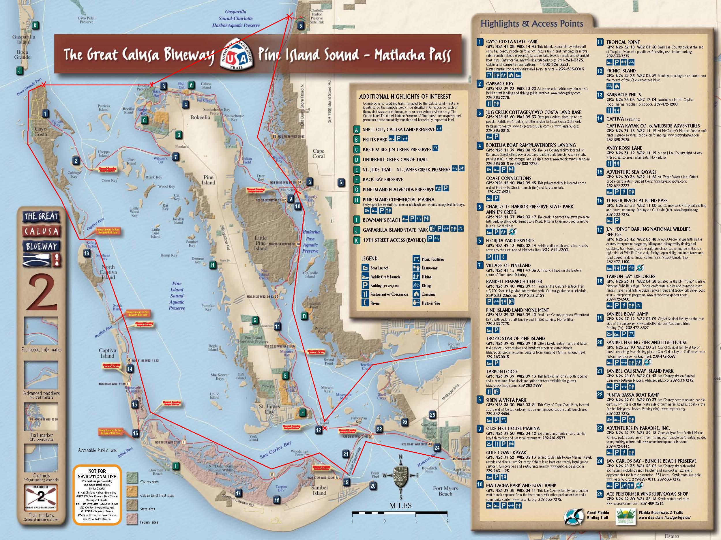
The Great Calusa Blueway Paddling Trail is a 190-mile marked canoe and kayak trail that meanders through the coastal waters and inland tributaries of Lee County, Florida.

 Paddling for a Cause
190 miles on southwest Florida’s Great Calusa Blueway


“Sometimes we forget how nice our backyard is,” Fabiszewski says. “Fresh water, salt flats, marsh, inner coastal, the Gulf of Mexico—and everything from mangroves to bamboo forest, to oaks … Florida has it all. And CROW is doing so much to save endangered animals, we wanted to do something to shed some light on that, too.”You can read more about their Calusa Blueway adventure or make a donation to either of the organizations on their blog, Liquidrythmnkayaking.com.
Fitzgibbon and Fabiszewski will also be hosting a presentation on their trip at the sixth annual Great Calusa Blueway Paddling Festival & Symposium, Nov. 3-6, along the beaches of the Calusa Blueway in the Fort Myers and Sanibel area in southwest Florida. While you’re there, check out the first-ever Calusa Classic 10-mile race or the Calusa Dash, a 5-mile standup paddleboard race. With over $2,000 in cash prizes, it’s worth getting on the water, even if you’re a beginner. Add onto that three days of boat and equipment demos, new product testing with Canoe & Kayak, on-water clinics, evening paddler’s socials (with refreshments), and a Canoe & Kayak Mag Film Fest Night, and it’s bound to be a good time.
Copyright © 2011 GrindMedia, LLC. All rights reserved.
The Day by Day description of our kayak trip.
September 18, 2011 – Let the Journey Begin!!

LEE COUNTY- Two men are to begin their expedition tomorrow to raise money for the Great Calusa Blueway Paddling Trail and Clinic for Rehabilitation of Wildlife.
(From http://www.fox4now.com)
Sean Fitzgibbon and Jeff Fabiszewski are experienced kayakers from the Tampa Bay area who have formed Team Sweetwater. The two plans on paddling the 190-mile marked and unmarked paddling trail in Lee County.
The Team is paddling to raise awareness for the Paddling Trail and the Clinic for Rehabilitation of Wildlife (CROW) which is on Sanibel Island. The public is encouraged to visit www.liquidrhythmkayaking.com to make a donation to both organizations. The expedition blog will be updated daily.
Team Sweetwater will return to Lee County on November 4-6 to teach a rescue class and speak about the expedition during the Great Calusa Blueway Paddling Festival and Symposium.
The expedition starts tomorrow, September 19th at 8 a.m. and goes until October 2nd.
Check back for updates on their paddle.
(Posted 22:00)
September 19, 2011 – They’re Off
Today is the offical first day of the trip and everything went well. The overnight pre-departure camping went without incident and they launched from Caloosahatchee Regional Park, which is located near Alva. Their first planned detour from the Caloosahatchee River was the Hickey Creek. Hickey Creek is actually a mitigation park implemented by the Florida Fish and Wildlife Conversation Commission (FWC). This mitigation area gives developers an alternative solution to creating mitigation areas on their development site. For additional information and a map of the area check out the Hickey_Creek_Information brochure.

After completing the creek and finding their way back to the Caloosahatchee, the journey continued downstream until they reached their first obstacle, the WP Franklin Lock and Dam. These locks were constructed by the Army Corps of Engineers in 1965 and are located approximately 33 miles from the Intercoastal Waterway. Their primary purpose is for flood control, water control, prevention of saltwater intrusion, and for navigational purposes. This is one of five locks the Corps constructed and maintains along the 152 mile Okeechobee Waterway. Unfortunately they were not able (allowed) to pass through these locks, so this became the first portage of the trip. Camping at Rock Creek Resort.
Trip details: Day 1: Caloosahatchee Regional Park to Rock Creek Resort via Hickey Creek. Miles covered – 20.1
September 20, 2011 – Downstream and Into Open Water

The journey continues by heading downstream to the mouth of the Caloosahatchee River and beyond. The destination for today is Picnic Island. Picnic Island located about three miles southwest of the mouth of the Caloosahatchee and about 1.5 miles southeast of Saint James City on Pine Island. If you are tracking their progress on Google Earth, it can be found at latitude 26°29’23.46”N, longitude 82°02’57.20”W.
For the most part it was a very uneventful day on the water, although their paddle was interrupted by an afternoon Florida rain shower. Both Jeff and Sean were surprised by the variety of marine life they encountered today and hopefully photos will follow when they return.
Trip details: Day 2: Rock Creek Resort to Picnic Island. Miles covered 19.1
September 21, 2011 – Heading North
 A highlight of today’s trip was the bald eagle they saw during today’s northerly trip. Otherwise the trip was uneventful except they had to perform some minor repairs to the boats. According to Jeff, the skeg on his kayak was sticking and would not function properly. The skeg on his kayak is rope operated and its mechanism is a combination of rope and bungee cords. So to resolve this issue he exited the kayak, flipped it over, pulled the skeg mechanism apart, washed it, and then reassembled it. He also said Sean’s boat, being a custom two piece design, needed to have the bolts tightened that connected the two sections together. Since this was not critical and since they did not have tools for this repair, they opted to delay repair until the end of today’s paddle.
 If you are interested in tracking their journey you can go to Google Earth and download their software. Once you have the program running Lee County Parks and Recreation offers a free KML plug-in that overlays Google Earth with the all of sign posts on the trip. You can either access the Lee County Parks and Recreation site and look for the KML files or click here to download them directly. Trip details: Day 3: Picnic Island (54) to Sun and Moon Inn (83). Miles covered 11.2
September 22, 2011 – Heading North
 Heading off around 9:30 a.m. this morning from the Sun and Moon Inn, Jeff and Sean were headed for their next destination, Bokeelia Island by way of marker 99 in Charlotte Harbor Preserve State Park. Marker 99 is the northern most point of the Calusa Blueway Trail and is located in the southeast corner of Charlotte Harbor on the mainland. Just a note about the park itself, it is not simply one land mass but rather multiple land masses that encompasses some 42,000 acres in Lee and Charlotte Counties. Unfortunately with weather moving in the northern leg of today’s journey was cut short when a decision was made, somewhere between markers 96 and 97, to head directly for Bokeelia Island. If you are following the journey on Google Earth and have downloaded the plugin from the September 21st posting, there is no actual sign post number giving you the location of Bokeelia Island. Bokeelia Island is located at the northern most tip of Pine Island, which is at the south end of Charlotte Harbor.
Arriving around 5:00 p.m. all is well and they will be staying at the Jug Creek Cottages for this evening. The next leg of the journey is to be to Cayo Casta; however, with the forecasted weather there is some discussion about making the trip tomorrow or whether a “weather day” would be in order. As of this blog no decision has been made. So at this point they are on schedule and where they should be. All of the boat repairs have been made and everyone is safe.
Trip details: Day 4: Sun and Moon Inn (83) in Matlacha to Jug Creek Cottages on Bokeelia Island. Miles covered 8+.
September 23, 2011 – Off to Cayo Costa
They left Jug Creek Cottages on Bokeelia Island and have traveled west to Cayo Costa State Park. During their trip they saw dolphins and a variety of other marine life. When they arrived on Cayo Costa they came ashore on the northeast corner of the island. The park service was gracious enough to provide ground transport for them to the Gulf side of the island. So for the next couple of days they will be enjoying the sun and fun of Cayo Costa.
Trip details: Day 5: Jug Creek Cottages to Cayo Costa State Park: Miles covered 10
September 24, 2011 – Day Off
Today was a planned day of rest with an extra day on Cayo Costa. This is their fifth day on the water and of promoting the Clinic for Rehabilitation of Wildlife (CROW) and the Great Calusa Blueway Trail to all they have met. Overall the response to those they have spoken has been excellent with many wanting additional information. In case you don’t know about CROW, they rely 100% on your charitable support. Their mission is to save wildlife through compassion, care and education. Donations and more information about CROW can be found at http://www.crowclinic.org.
It rained last night and much to their amazement they found that Jeff’s tent leaks around the skylight. However since there was no mention of how bad the leak was or if they were going to try and repair it, it’s probably not bad but rather an inconvenience. When I spoke with Sean he was quick to point out that his hammock and tarp combination were dry but he also had a concern for this accommodations. It appears a nest of bees has appeared relativity close to the entrance to his hammock, so he is being very careful when he enters and exits his hammock so as not to disturb his new neighbors.
During the day they have met some of the other tourists and campers on the island. One couple was kayaking around the island geocaching. “Geocaching is a real-world outdoor treasure hunting game. Players try to locate hidden containers, called geocaches, using GPS-enabled devices and then share their experiences online.” If you want to find out more on geocaching, click here. Another group of five individuals was celebrating one of their members birthday. Being tourist to the island and festive, they extended an offer to Jeff and Sean to partake of their hospitality and libations.
Jeff is teaching Sean how to play a game called Hive. Not quite sure if this is a board game or a card game. Check back on tomorrow’s blog for an answer and maybe how it’s played.
While not a long or particularity treacherous trip thus far, they are finding that day six away from family brings with it thoughts of missing kids and family members.
Tomorrow’s float plan is to break camp in the morning and head for the northern end of Sanibel.
Trip details: Day 6: Staying put.
September 25, 2011 – Turning South and on to Sanibel Island
They are on the move again and heading south. A special thanks to the park service on Cayo Costa for transporting Team Sweetwater (Jeff and Sean) back to their boats on the east side of the island. Heading south their destination is Sanibel Island. Along the way they will also pass North Captiva Island and Captiva Island. A brief history of the islands states “… these barrier islands were dominated by the fierce Calusa Indians.” “The [Spanish] conquistadors nearly wiped out the entire Calusa population in a series of battles and enslaved the remaining few in Cuban prison camps, where they eventually died.” Jose Gaspar also used these islands for the repairing of his ships. It is rumored that Jose may have buried his treasure on Sanibel Island.

They arrived on the north end of Sanibel Island earlier today without any on water incidents. The only comment Jeff made was that it was HOT!! Temperature, according the Weather Underground, was in the high 80’s day.
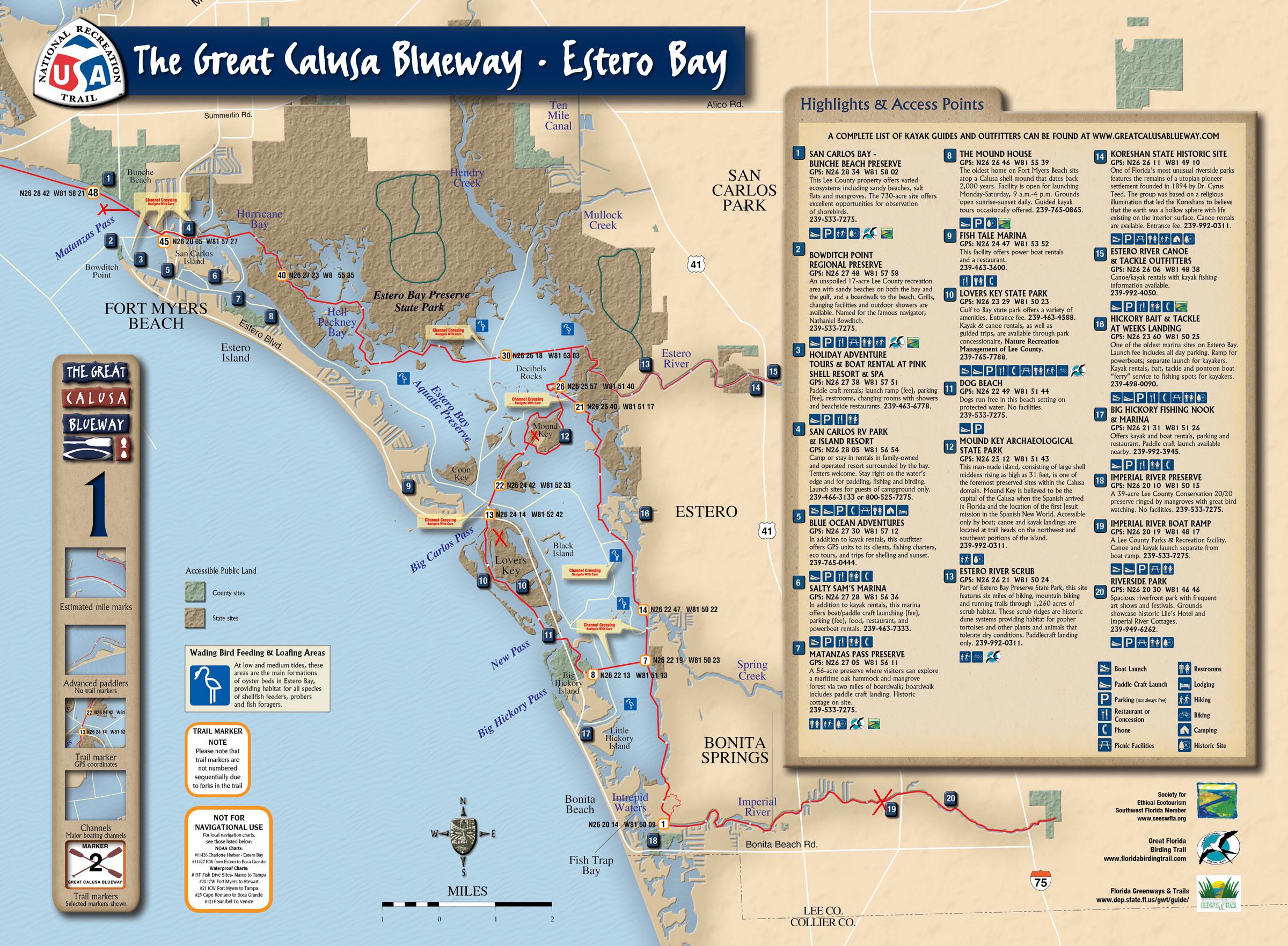
Dinner was at the Lazy Flamingo Restaurant again. They have managed to stop at two of the four locations. Can they find the other two? Only time will tell. As for lodging, they will be at the Castaways Beach and Bay Cottages this evening. The Castaways is located just a stone’s throw from Blind Pass Bridge.![]() The Clinic for the Rehabilitation of Wildlife (CROW) was established on the island in 1968 and is towards the other end of the island from the Castaways. “It is a non-profit corporation dedicated to the rescue and rehabilitation of sick, orphaned and injured wildlife. C.R.O.W. has a complete wildlife hospital at the middle of its 12.5 acre sanctuary. The clinic focuses on education in an effort to prevent injuries to animals caused by human interference. Guided presentations are given year around.”
The Clinic for the Rehabilitation of Wildlife (CROW) was established on the island in 1968 and is towards the other end of the island from the Castaways. “It is a non-profit corporation dedicated to the rescue and rehabilitation of sick, orphaned and injured wildlife. C.R.O.W. has a complete wildlife hospital at the middle of its 12.5 acre sanctuary. The clinic focuses on education in an effort to prevent injuries to animals caused by human interference. Guided presentations are given year around.”
Facts and Figures: Today’s travel was 16.2 miles and it took them about 5 ¼ hours. This amounts to an average of 3.1 mph, which has been about the average thus far for the trip.Trip details: Day 7: Cayo Costa State Park to the Castaways on Sanibel Island: Miles covered 16.2
September 26, 2011 – Visiting CROW and Hitting the Road
![]()

Most of today was spent visiting at the Clinic for the Rehabilitation of Wildlife (CROW). As mentioned previously CROW is located on 12.5 acres on Sanibel Island, south of the Castaways Beach and Bay Cottages, on Sanibel-Captive Road. While there Jeff and Sean were given a tour of the facility and met some of the current patients, which included raccoons, turtles, and birds.

The clinic is fortunate to receive donations of fruit and vegetables from the local markets. While this helps to reduce the cost of feeding their patients, they still need tax deductable donations to purchase the mice and fish protein that is needed. Some of the new arrivals included several seagulls. According to the staff the birds fell out of their nest and were brought to the center in a McDonalds’ happy meal box.
So hitting the road, not paddling, they find themselves on San Carlos Island this evening. Transportation was courtesy of a fellow kayaker who was kind enough to drive them off the island and shuttle them to the San Carlos RV Park and Island Resort (marker 44).
Once at the RV park and island resort the next major decision of the day was food. Do they head next door for the all you can eat blue crabs at Maria’s Backwater Bar and Grill or venture to the Nuauti Turtle. Just for those of who are were wondering, Team Sweetwater will not be visiting all of the Lazy Flamingo locations,  they skipped the one on the southern tip of Sanibel.
Just a great thanks to the San Carlos RV Park and Island Resort for rescuing Jeff and Sean from the downpour last evening by upgrading them to a SUPER RV. They really enjoyed watching television while sitting on nice comfy (dry) furniture.
They are back on the water tomorrow and headed for Koreshan State Park. Koreshan is located upstream from Estero Bay.
Trip details: Day 8: Sightseeing and shuttle ride
September 27-28 2011 – Koreshan State Park

They arrive at Koreshan State Park early this afternoon. The plans for tomorrow include staying at Koreshan State Park for second night. This does not mean a day off the water, but rather a chance to go and visit Mound Key Archeological State Park. Mound Key is located near the mouth of Estero River and is believed to have been the capitol for the Calusa tribe. More on Mound Key tomorrow.
If you are tracking Team Sweetwater’s trek on Google Earth you can look for markers 24, 25, and 25a. Can’t find the markers, download the plug-in here. Thursday will have them moving to Big Hickory State Park.
Trip details: Day 9: San Carlos Island RV Park and Island Resort (44) to Koreshan State Park. Miles: 11.1 Averaged 3.1 mph.
September 28, 2011 – Day Off
Team Sweetwater (Jeff and Sean) spent most of Wednesday the 28th, exploring the sights, sounds of Koreshan State Park.
Trip details: Day 10: Explore Koreshan State Park.
September 29th, 2011 – Onto Big Hickey Island and then Home
 Today we find them back on the water and headed for Big Hickey Island with a planned detour to Mound Key Archeological State Park for some exploring. The wildlife on and around the water was abundant with the sightings of manatees, dolphins, roseate spoon bills, night herons, and loons. Upon reaching Big Hickey Island they both commented on how new the campsite was as it was recently cleared and still contained piles of ashes from the clear cutting and burning.
Tomorrow will mark the end of the trip when they take out at Imperial River boat ramp. What to know more about the journey? Come to the Calusa Blueways Paddling Festival, November 3rd to the 6th off the beaches of Fort Myers and Sanibel. Check out the schedule of events and be part of the festivities.
Please don’t forget about Team Sweetwater’s sponsor of choice Clinic for Rehabilitation of Wildlife (CROW) and how desperately they need donations of either money or supplies. If you have the opportunity and have some spare time volunteer at the clinic.
Trip details: Day 11 Koreshan State Park to Big Hickey Island via Mound Key Archeological State Park. Miles: 8.44. Averaged 3.1 mph.

I am in fact delighted to read this webpage posts which consists of plenty of valuable facts,
thanks for providing these information.